Weather Alert in Alaska
Winter Storm Warning issued February 28 at 5:49AM AKST until February 28 at 9:00PM AKST by NWS Juneau AK
AREAS AFFECTED: Glacier Bay; Eastern Chichagof Island; Cape Fairweather to Lisianski Strait
DESCRIPTION: ...CENTRAL AND SOUTHERN PANHANDLE SNOW SATURDAY WITH POTENTIAL FOR MORE SNOW SUNDAY... Snowfall has increased in intensity and coverage overnight as a low tracks eastward across the Gulf towards the central panhandle. An estimated 2 to 4 inches has fallen overnight, these accumulations are separate from the next system set to affect the area through Saturday. Steady snowfall will continue through Saturday morning with rates increasing through the afternoon. Heaviest snowfall rates are expected to start by mid day along the coast, spreading eastward towards Hyder through Saturday night. As the low center tracks eastward through Saturday afternoon and evening, south to southwest wind will cause temperatures to warm over the southern outer coast with a mix or change to rain. Snow will then end on the NW side of the low, from Sitka to Juneau northward. Moisture will decrease overnight Saturday across the south, but then redevelop on Sunday as another system moves in. The rain/snow line will likely hover in vicinity of Sumner Strait Sunday into Monday with potential additional heavy snow for the Petersburg and Wrangell areas and lighter snow northward. A separate low pressure system looks to affect the region on Tuesday with potential for snow to push northward again. * WHAT...Heavy snow expected. Total snow accumulations of 5 to 10 inches. * WHERE...Gustavus, Hoonah, Tenakee Springs, Pelican, and Elfin Cove. * WHEN...Until 9 PM AKST Saturday. * IMPACTS...Travel will be difficult. * ADDITIONAL DETAILS...Heaviest snowfall rates will be mid day Saturday.
INSTRUCTION: If you must travel, keep an extra flashlight, food, and water with you in case of an emergency. People are urged to prepare their property before the onset of winter weather. For the latest road conditions, where available, call 5 1 1 or visit 511.alaska.gov.
Want more detail? Get the Complete 7 Day and Night Detailed Forecast!
Current U.S. National Radar--Current
The Current National Weather Radar is shown below with a UTC Time (subtract 5 hours from UTC to get Eastern Time).

National Weather Forecast--Current
The Current National Weather Forecast and National Weather Map are shown below.

National Weather Forecast for Tomorrow
Tomorrow National Weather Forecast and Tomorrow National Weather Map are show below.

North America Water Vapor (Moisture)
This map shows recent moisture content over North America. Bright and colored areas show high moisture (ie, clouds); brown indicates very little moisture present; black indicates no moisture.

Weather Topic: What is Condensation?
Home - Education - Precipitation - Condensation
 Next Topic: Contrails
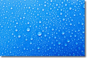
Condensation is the process which creates clouds, and therefore
it is a crucial process in the water cycle.
Condensation is the change of matter from a state of gas into a state of liquid,
and it happens because water molecules release heat into the atmosphere and
become organized into a more closely packed structure, what we might see as
water droplets.
Water is always present in the air around us as a vapor, but it's too small for
us to see. When water undergoes the process of condensation it becomes organized
into visible water droplets. You've probably seen condensation happen before on the
surface of a cold drink!
Next Topic: Contrails
Weather Topic: What are Cumulonimbus Clouds?
Home - Education - Cloud Types - Cumulonimbus Clouds
 Next Topic: Cumulus Clouds
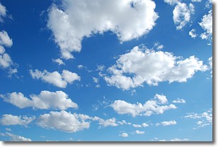
The final form taken by a growing cumulus cloud is the
cumulonimbus cloud, which is very tall and dense.
The tower of a cumulonimbus cloud can soar 23 km into the atmosphere, although
most commonly they stop growing at an altitude of 6 km.
Even small cumulonimbus clouds appear very large in comparison to other cloud types.
They can signal the approach of stormy weather, such as thunderstorms or blizzards.
Next Topic: Cumulus Clouds
Current conditions powered by WeatherAPI.com


