Weather Alert in Wyoming
High Wind Watch issued February 23 at 11:56AM MST until February 25 at 5:00PM MST by NWS Riverton WY
AREAS AFFECTED: Green Mountains and Rattlesnake Range; Natrona County Lower Elevations
DESCRIPTION: * WHAT...West winds 30 to 40 mph with gusts up to 60 mph across lower elevations of Natrona County; West winds 30 to 40 mph with gusts up to 70 mph across the Green Mountains and Rattlesnake Range. * WHERE...Green Mountains and Rattlesnake Range and Natrona County Lower Elevations. * WHEN...From 8 AM MST Wednesday morning through 5 PM MST Wednesday evening. * IMPACTS...Travel could be difficult, especially for high profile vehicles. * ADDITIONAL DETAILS...The strongest wind gusts are expected to occur along Wyoming Highway 287 from Jeffery City to Muddy Gap, as well as Highway 258 on the south side of Casper.
INSTRUCTION: Use caution if you must drive.
Want more detail? Get the Complete 7 Day and Night Detailed Forecast!
Current U.S. National Radar--Current
The Current National Weather Radar is shown below with a UTC Time (subtract 5 hours from UTC to get Eastern Time).

National Weather Forecast--Current
The Current National Weather Forecast and National Weather Map are shown below.

National Weather Forecast for Tomorrow
Tomorrow National Weather Forecast and Tomorrow National Weather Map are show below.

North America Water Vapor (Moisture)
This map shows recent moisture content over North America. Bright and colored areas show high moisture (ie, clouds); brown indicates very little moisture present; black indicates no moisture.

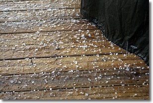
Weather Topic: What is Sleet?
Home - Education - Precipitation - Sleet
 Next Topic: Snow
Sleet is a form of precipitation in which small ice pellets are the primary
components. These ice pellets are smaller and more translucent than hailstones,
and harder than graupel. Sleet is caused by specific atmospheric conditions and
therefore typically doesn't last for extended periods of time.
The condition which leads to sleet formation requires a warmer body of air to be
wedged in between two sub-freezing bodies of air. When snow falls through a warmer
layer of air it melts, and as it falls through the next sub-freezing body of air
it freezes again, forming ice pellets known as sleet. In some cases, water
droplets don't have time to freeze before reaching the surface and the result is
freezing rain.
Next Topic: Snow
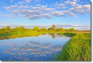
Weather Topic: What are Stratocumulus Clouds?
Home - Education - Cloud Types - Stratocumulus Clouds
 Next Topic: Stratus Clouds
Stratocumulus clouds are similar to altocumulus clouds in their
fluffy appearance, but have a slightly darker shade due to their additional mass.
A good way to distinguish the two cloud types is to hold your hand out and measure
the size of an individual cloud; if it is the size of your thumb it is generally
an altocumulus cloud, if it is the size of your hand it is generally a
stratocumulus cloud.
It is uncommon for stratocumulus clouds to produce precipitation, but if they do
it is usually a light rain or snow.
Next Topic: Stratus Clouds
Current conditions powered by WeatherAPI.com


