Weather Alert in Texas
Flood Warning issued May 1 at 8:56PM CDT until May 2 at 1:00PM CDT by NWS Fort Worth TX
AREAS AFFECTED: Hunt, TX; Rockwall, TX
DESCRIPTION: ...The Flood Warning is extended for the following rivers in Texas... Cowleech Fork Sabine River At Greenville affecting Hunt County. South Fork Sabine River Near Quinlan affecting Rockwall and Hunt Counties. Big Sandy Creek Near Bridgeport affecting Wise County. West Fork Trinity River Near Jacksboro affecting Jack County. Denton Creek Near Justin affecting Denton County. Trinity River At Dallas affecting Dallas County. Trinity River Near Long Lake (Oakwood) affecting Anderson, Leon and Freestone Counties. Brazos River Near South Bend affecting Young County. ...The Flood Warning continues for the following rivers in Texas... West Fork Trinity River Near Boyd affecting Wise County. Trinity River At Trinidad affecting Henderson and Navarro Counties. ...The Flood Warning is cancelled for the following rivers in Texas... Chambers Creek Near Rice affecting Navarro County. * WHAT...Minor flooding is occurring and minor flooding is forecast. * WHERE...South Fork Sabine River near Quinlan. * WHEN...Until early tomorrow afternoon. * IMPACTS...At 15.0 feet, Minor out of bank flooding will occur. * ADDITIONAL DETAILS... - At 7:45 PM CDT Thursday the stage was 15.5 feet. - Bankfull stage is 15.0 feet. - Flood stage is 15.0 feet. - Forecast...The river is expected to fall below flood stage just after midnight tonight and continue falling to 5.6 feet Tuesday evening.
INSTRUCTION: Do not drive cars through flooded areas. Caution is urged when walking near riverbanks. Additional information is available at www.water.noaa.gov/wfo/FWD.
Want more detail? Get the Complete 7 Day and Night Detailed Forecast!
Current U.S. National Radar--Current
The Current National Weather Radar is shown below with a UTC Time (subtract 5 hours from UTC to get Eastern Time).

National Weather Forecast--Current
The Current National Weather Forecast and National Weather Map are shown below.

National Weather Forecast for Tomorrow
Tomorrow National Weather Forecast and Tomorrow National Weather Map are show below.

North America Water Vapor (Moisture)
This map shows recent moisture content over North America. Bright and colored areas show high moisture (ie, clouds); brown indicates very little moisture present; black indicates no moisture.

Weather Topic: What is Snow?
Home - Education - Precipitation - Snow
 Next Topic: Stratocumulus Clouds
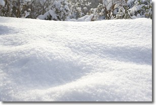
Snow is precipitation taking the form of ice crystals. Each ice crystal, or snowflake,
has unique characteristics, but all of them grow in a hexagonal structure.
Snowfall can last for sustained periods of time and result in significant buildup
of snow on the ground.
On the earth's surface, snow starts out light and powdery, but as it begins to melt
it tends to become more granular, producing small bits of ice which have the consistency of
sand. After several cycles of melting and freezing, snow can become very dense
and ice-like, commonly known as snow pack.
Next Topic: Stratocumulus Clouds
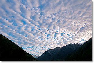
Weather Topic: What are Stratus Clouds?
Home - Education - Cloud Types - Stratus Clouds
 Next Topic: Wall Clouds
Stratus clouds are similar to altostratus clouds, but form at a
lower altitude and are identified by their fog-like appearance, lacking the
distinguishing features of most clouds.
Stratus clouds are wider than most clouds, and their base has a smooth, uniform
look which is lighter in color than a nimbostratus cloud.
The presence of a stratus cloud indicates the possibility of minor precipitation,
such as drizzle, but heavier precipitation does not typically arrive in the form
of a stratus cloud.
Next Topic: Wall Clouds
Current conditions powered by WeatherAPI.com


