Weather Alert in Montana
High Wind Watch issued March 5 at 11:28PM MST until March 7 at 11:00PM MST by NWS Great Falls MT
AREAS AFFECTED: Western and Central Chouteau County; Bears Paw Mountains and Southern Blaine; Cascade County below 5000ft; Judith Basin County and Judith Gap; Fergus County below 4500ft
DESCRIPTION: * WHAT...For the first High Wind Watch, west winds 30 to 40 mph, with gusts up to 60 mph possible. For the second High Wind Watch, west winds 30 to 50 mph with gusts up to 70 mph possible. * WHERE...Bears Paw Mountains and Southern Blaine, Cascade County below 5000ft, Fergus County below 4500ft, Judith Basin County and Judith Gap, and Western and Central Chouteau County. * WHEN...For the first High Wind Watch, from Saturday morning through Saturday evening. For the second High Wind Watch, from Sunday morning through Sunday evening. * IMPACTS...High winds may move loose debris, damage property and cause power outages. Travel could be very difficult to dangerous, especially for high profile vehicles. Damaging winds may blow down trees and power lines. * ADDITIONAL DETAILS...The magnitude and duration of the winds on Sunday are expected to be similar to the December 17th event.
INSTRUCTION: Monitor the latest forecasts and warnings for updates. Remember, a High Wind Watch means that there is at least a 50% chance of 40 mph sustained winds or 58 mph wind gusts occurring during the watch period.
Want more detail? Get the Complete 7 Day and Night Detailed Forecast!
Current U.S. National Radar--Current
The Current National Weather Radar is shown below with a UTC Time (subtract 5 hours from UTC to get Eastern Time).

National Weather Forecast--Current
The Current National Weather Forecast and National Weather Map are shown below.

National Weather Forecast for Tomorrow
Tomorrow National Weather Forecast and Tomorrow National Weather Map are show below.

North America Water Vapor (Moisture)
This map shows recent moisture content over North America. Bright and colored areas show high moisture (ie, clouds); brown indicates very little moisture present; black indicates no moisture.

Weather Topic: What are Wall Clouds?
Home - Education - Cloud Types - Wall Clouds
 Next Topic: Altocumulus Clouds
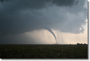
A wall cloud forms underneath the base of a cumulonimbus cloud,
and can be a hotbed for deadly tornadoes.
Wall clouds are formed by air flowing into the cumulonimbus clouds, which can
result in the wall cloud descending from the base of the cumulonimbus cloud, or
rising fractus clouds which join to the base of the storm cloud as the wall cloud
takes shape.
Wall clouds can be very large, and in the Northern Hemisphere they generally
form at the southern edge of cumulonimbus clouds.
Next Topic: Altocumulus Clouds
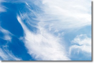
Weather Topic: What are Altostratus Clouds?
Home - Education - Cloud Types - Altostratus Clouds
 Next Topic: Cirrocumulus Clouds
Altostratus clouds form at mid to high-level altitudes
(between 2 and 7 km) and are created by a warm, stable air mass which causes
water vapor
to condense as it rise through the atmosphere. Usually altostratus clouds are
featureless sheets characterized by a uniform color.
In some cases, wind punching through the cloud formation may give it a waved
appearance, called altostratus undulatus. Altostratus clouds
are commonly seen with other cloud formations accompanying them.
Next Topic: Cirrocumulus Clouds
Current conditions powered by WeatherAPI.com


