Weather Alert in Montana
High Wind Watch issued March 5 at 11:28PM MST until March 8 at 11:00PM MST by NWS Great Falls MT
AREAS AFFECTED: Western and Central Chouteau County; Bears Paw Mountains and Southern Blaine; Cascade County below 5000ft; Judith Basin County and Judith Gap; Fergus County below 4500ft
DESCRIPTION: * WHAT...For the first High Wind Watch, west winds 30 to 40 mph, with gusts up to 60 mph possible. For the second High Wind Watch, west winds 30 to 50 mph with gusts up to 70 mph possible. * WHERE...Bears Paw Mountains and Southern Blaine, Cascade County below 5000ft, Fergus County below 4500ft, Judith Basin County and Judith Gap, and Western and Central Chouteau County. * WHEN...For the first High Wind Watch, from Saturday morning through Saturday evening. For the second High Wind Watch, from Sunday morning through Sunday evening. * IMPACTS...High winds may move loose debris, damage property and cause power outages. Travel could be very difficult to dangerous, especially for high profile vehicles. Damaging winds may blow down trees and power lines. * ADDITIONAL DETAILS...The magnitude and duration of the winds on Sunday are expected to be similar to the December 17th event.
INSTRUCTION: Monitor the latest forecasts and warnings for updates. Remember, a High Wind Watch means that there is at least a 50% chance of 40 mph sustained winds or 58 mph wind gusts occurring during the watch period.
Want more detail? Get the Complete 7 Day and Night Detailed Forecast!
Current U.S. National Radar--Current
The Current National Weather Radar is shown below with a UTC Time (subtract 5 hours from UTC to get Eastern Time).

National Weather Forecast--Current
The Current National Weather Forecast and National Weather Map are shown below.

National Weather Forecast for Tomorrow
Tomorrow National Weather Forecast and Tomorrow National Weather Map are show below.

North America Water Vapor (Moisture)
This map shows recent moisture content over North America. Bright and colored areas show high moisture (ie, clouds); brown indicates very little moisture present; black indicates no moisture.

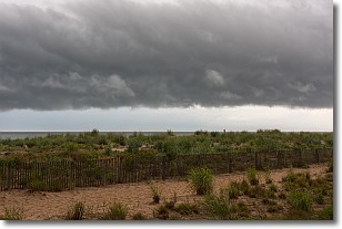
Weather Topic: What are Shelf Clouds?
Home - Education - Cloud Types - Shelf Clouds
 Next Topic: Sleet
A shelf cloud is similar to a wall cloud, but forms at the front
of a storm cloud, instead of at the rear, where wall clouds form.
A shelf cloud is caused by a series of events set into motion by the advancing
storm; first, cool air settles along the ground where precipitation has just fallen.
As the cool air is brought in, the warmer air is displaced, and rises above it,
because it is less dense. When the warmer air reaches the bottom of the storm cloud,
it begins to cool again, and the resulting condensation is a visible shelf cloud.
Next Topic: Sleet
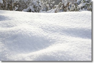
Weather Topic: What is Snow?
Home - Education - Precipitation - Snow
 Next Topic: Stratocumulus Clouds
Snow is precipitation taking the form of ice crystals. Each ice crystal, or snowflake,
has unique characteristics, but all of them grow in a hexagonal structure.
Snowfall can last for sustained periods of time and result in significant buildup
of snow on the ground.
On the earth's surface, snow starts out light and powdery, but as it begins to melt
it tends to become more granular, producing small bits of ice which have the consistency of
sand. After several cycles of melting and freezing, snow can become very dense
and ice-like, commonly known as snow pack.
Next Topic: Stratocumulus Clouds
Current conditions powered by WeatherAPI.com


