Weather Alert in South Carolina
Flash Flood Warning issued August 22 at 2:17PM EDT until August 22 at 4:00PM EDT by NWS Charleston SC
AREAS AFFECTED: Charleston, SC
DESCRIPTION: FFWCHS The National Weather Service in Charleston has extended the * Flash Flood Warning for... Charleston County in southeastern South Carolina... * Until 400 PM EDT. * At 217 PM EDT, emergency management reported roads remain closed in parts of Mount Pleasant. While rain will continue to diminish, it will take some time for flood waters to recede. Between 2 and 4 inches of rain has fallen in some areas this afternoon. HAZARD...Flash flooding caused by thunderstorms. SOURCE...Emergency management reported. IMPACT...Flash flooding of small creeks and streams, urban areas, highways, streets and underpasses as well as other poor drainage and low-lying areas. * Some locations that will experience flash flooding include... Mount Pleasant, Isle Of Palms, Sullivan's Island, Mount Pleasant Towne Centre, Boone Hall Plantation, Sullivans Island, Seaside Farms, East Cooper Regional Medical Center, Hamlin Plantation and Snowden. This includes I-526 between mile markers 29 and 31.
INSTRUCTION: Turn around, don't drown when encountering flooded roads. Most flood deaths occur in vehicles.
Want more detail? Get the Complete 7 Day and Night Detailed Forecast!
Current U.S. National Radar--Current
The Current National Weather Radar is shown below with a UTC Time (subtract 5 hours from UTC to get Eastern Time).

National Weather Forecast--Current
The Current National Weather Forecast and National Weather Map are shown below.

National Weather Forecast for Tomorrow
Tomorrow National Weather Forecast and Tomorrow National Weather Map are show below.

North America Water Vapor (Moisture)
This map shows recent moisture content over North America. Bright and colored areas show high moisture (ie, clouds); brown indicates very little moisture present; black indicates no moisture.

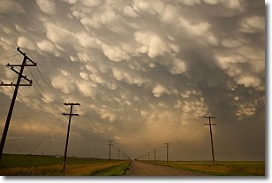
Weather Topic: What are Mammatus Clouds?
Home - Education - Cloud Types - Mammatus Clouds
 Next Topic: Nimbostratus Clouds
A mammatus cloud is a cloud with a unique feature which resembles
a web of pouches hanging along the base of the cloud.
In the United States, mammatus clouds tend to form in the warmer months, commonly
in the Midwest and eastern regions.
While they usually form at the bottom of a cumulonimbis cloud, they can also form
under altostratus, altocumulus, stratocumulus, and cirrus clouds. Mammatus clouds
warn that severe weather is close.
Next Topic: Nimbostratus Clouds
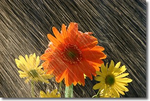
Weather Topic: What is Precipitation?
Home - Education - Precipitation - Precipitation
 Next Topic: Rain
Precipitation can refer to many different forms of water that
may fall from clouds. Precipitation occurs after a cloud has become saturated to
the point where its water particles are more dense than the air below the cloud.
In most cases, precipitation will reach the ground, but it is not uncommon for
precipitation to evaporate before it reaches the earth's surface.
When precipitation evaporates before it contacts the ground it is called Virga.
Graupel, hail, sleet, rain, drizzle, and snow are forms of precipitation, but fog
and mist are not considered precipitation because the water vapor which
constitutes them isn't dense enough to fall to the ground.
Next Topic: Rain
Current conditions powered by WeatherAPI.com


