Weather Alert in Arizona
Flood Watch issued September 4 at 1:28AM MST until September 5 at 12:00AM MST by NWS Phoenix AZ
AREAS AFFECTED: Aguila Valley; Northwest Valley; Tonopah Desert; Gila Bend; Buckeye/Avondale; Cave Creek/New River; Deer Valley; Central Phoenix; North Phoenix/Glendale; New River Mesa; Scottsdale/Paradise Valley; Rio Verde/Salt River; East Valley; Fountain Hills/East Mesa; South Mountain/Ahwatukee; Southeast Valley/Queen Creek; Superior; Northwest Pinal County; West Pinal County; Apache Junction/Gold Canyon; Tonto Basin; Mazatzal Mountains; Pinal/Superstition Mountains; Sonoran Desert Natl Monument; San Carlos; Dripping Springs; Globe/Miami; Southeast Gila County
DESCRIPTION: * WHAT...Flooding caused by excessive rainfall continues to be possible. * WHERE...A portion of south central Arizona, including the following areas, Aguila Valley, Apache Junction/Gold Canyon, Buckeye/Avondale, Cave Creek/New River, Central Phoenix, Deer Valley, Dripping Springs, East Valley, Fountain Hills/East Mesa, Gila Bend, Globe/Miami, Mazatzal Mountains, New River Mesa, North Phoenix/Glendale, Northwest Pinal County, Northwest Valley, Pinal/Superstition Mountains, Rio Verde/Salt River, San Carlos, Scottsdale/Paradise Valley, Sonoran Desert Natl Monument, South Mountain/Ahwatukee, Southeast Gila County, Southeast Valley/Queen Creek, Superior, Tonopah Desert, Tonto Basin and West Pinal County. * WHEN...From noon MST today through this evening. * IMPACTS...Excessive runoff may result in flooding of rivers, creeks, streams, and other low-lying and flood-prone locations. Low-water crossings may be flooded. * ADDITIONAL DETAILS... - High atmospheric moisture content in combination with slow moving showers and thunderstorms may result in heavy rainfall and flooding in the watch area. - http://www.weather.gov/safety/flood
INSTRUCTION: You should monitor later forecasts and be alert for possible Flood Warnings. Those living in areas prone to flooding should be prepared to take action should flooding develop.
Want more detail? Get the Complete 7 Day and Night Detailed Forecast!
Current U.S. National Radar--Current
The Current National Weather Radar is shown below with a UTC Time (subtract 5 hours from UTC to get Eastern Time).

National Weather Forecast--Current
The Current National Weather Forecast and National Weather Map are shown below.

National Weather Forecast for Tomorrow
Tomorrow National Weather Forecast and Tomorrow National Weather Map are show below.

North America Water Vapor (Moisture)
This map shows recent moisture content over North America. Bright and colored areas show high moisture (ie, clouds); brown indicates very little moisture present; black indicates no moisture.

Weather Topic: What are Altostratus Clouds?
Home - Education - Cloud Types - Altostratus Clouds
 Next Topic: Cirrocumulus Clouds
Altostratus clouds form at mid to high-level altitudes
(between 2 and 7 km) and are created by a warm, stable air mass which causes
water vapor
to condense as it rise through the atmosphere. Usually altostratus clouds are
featureless sheets characterized by a uniform color.
In some cases, wind punching through the cloud formation may give it a waved
appearance, called altostratus undulatus. Altostratus clouds
are commonly seen with other cloud formations accompanying them.
Next Topic: Cirrocumulus Clouds
Weather Topic: What are Cirrostratus Clouds?
Home - Education - Cloud Types - Cirrostratus Clouds
 Next Topic: Cirrus Clouds
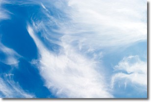
Cirrostratus clouds are high, thin clouds that form above
20,000 feet and are made mostly of ice crystals. They sometimes look like giant
feathers, horse tails, or curls of hair in the sky.
These clouds are pushed by the jet stream and can move at high speeds reaching
100 mph.
What do they indicate?
They indicate that a precipitation is likely within 24 hours.
Next Topic: Cirrus Clouds
Current conditions powered by WeatherAPI.com


