Weather Alert in Wisconsin
Special Weather Statement issued August 22 at 3:25PM CDT by NWS Green Bay WI
AREAS AFFECTED: Vilas; Oneida
DESCRIPTION: At 324 PM CDT, Doppler radar was tracking a cluster of strong thunderstorms along a line extending from 7 miles northeast of Border Lakes Natural Area to 6 miles southwest of Boulder Junction to near Willow Lake. Movement was east at 35 mph. HAZARD...Wind gusts up to 40 mph. SOURCE...Radar indicated. IMPACT...Gusty winds could knock down tree limbs and blow around unsecured objects. Strong thunderstorms will be near... Boulder Junction, Squirrel Lake, and Willow Lake around 330 PM CDT. Johnson Lake Barrens Natural Area around 335 PM CDT. Willow Reservoir around 340 PM CDT. Rainbow Flowage around 355 PM CDT. Eagle River around 410 PM CDT. Phelps around 420 PM CDT. Other locations impacted by these storms include Mc Naughton, Sayner, Land O Lakes, Nixon Lake Natural Area, Lac Vieux Desert, Harshaw, Hazelhurst, Upper Buckatabon Springs Natural Area, Woodruff, and St Germain.
INSTRUCTION: If outdoors, consider seeking shelter inside a building. Persons in campgrounds should consider seeking sturdy shelter until these storms pass.
Want more detail? Get the Complete 7 Day and Night Detailed Forecast!
Current U.S. National Radar--Current
The Current National Weather Radar is shown below with a UTC Time (subtract 5 hours from UTC to get Eastern Time).

National Weather Forecast--Current
The Current National Weather Forecast and National Weather Map are shown below.

National Weather Forecast for Tomorrow
Tomorrow National Weather Forecast and Tomorrow National Weather Map are show below.

North America Water Vapor (Moisture)
This map shows recent moisture content over North America. Bright and colored areas show high moisture (ie, clouds); brown indicates very little moisture present; black indicates no moisture.

Weather Topic: What is Freezing Rain?
Home - Education - Precipitation - Freezing Rain
 Next Topic: Graupel
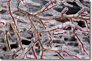
Freezing rain is a condition where precipitation which has fallen in the form of
water droplets reaches temperatures which are below freezing and freezes upon
coming into contact
with surface objects. The result of this precipitation is a glaze of ice which
can be damaging to plants and man-made structures. A severe onset of freezing
rain which results in a very thick glaze of ice is known as an ice storm.
Next Topic: Graupel
Weather Topic: What is Hail?
Home - Education - Precipitation - Hail
 Next Topic: Hole Punch Clouds
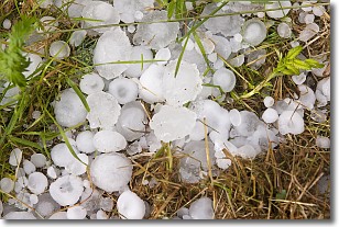
Hail is a form of precipitation which is recognized by large solid balls or
clumps of ice. Hail is created by thunderstorm clouds with strong updrafts of wind.
As the hailstones remain in the updraft, ice is deposited onto them until their
weight becomes heavy enough for them to fall to the earth's surface.
Hail storms can cause significant damage to crops, aircrafts, and man-made structures,
despite the fact that the duration is usually less than ten minutes.
Next Topic: Hole Punch Clouds
Current conditions powered by WeatherAPI.com


