Weather Alert in California
Air Quality Alert issued September 3 at 4:06PM PDT by NWS Hanford CA
AREAS AFFECTED: Fresno, CA; Kern, CA; Kings, CA; Madera, CA; Merced, CA; San Joaquin, CA; Stanislaus, CA; Tulare, CA
DESCRIPTION: The Valley Air District is issuing an Air Quality Alert on September 3, 2025, due to smoke impacts from wildfires in California including the Garnet Fire, the Marmon Fire, the Salt 11-2 Fire, and the TCU September Lightning Complex for San Joaquin, Stanislaus, Merced, Madera, Fresno, Kings, Tulare, and the Valley portion of Kern Counties. This Air Quality Alert is in effect until the fires are extinguished. Exposure to particle pollution can cause serious health problems, aggravate lung disease, cause asthma attacks and acute bronchitis, and increase risk of respiratory infections. Residents are advised to use caution as conditions warrant. People with heart or lung diseases should follow their doctors advice for dealing with episodes of unhealthy air quality. Additionally, older adults and children should avoid prolonged exposure, strenuous activities or heavy exertion, as conditions dictate. For additional information, call your local San Joaquin Valley Air District office. Modesto 209-557-6400, Fresno 559-230-6000, Bakersfield 661-392-5500 Residents can also follow air quality conditions by downloading the free Valley Air app, available in the Apple store or Google Play.
INSTRUCTION: N/A
Want more detail? Get the Complete 7 Day and Night Detailed Forecast!
Current U.S. National Radar--Current
The Current National Weather Radar is shown below with a UTC Time (subtract 5 hours from UTC to get Eastern Time).

National Weather Forecast--Current
The Current National Weather Forecast and National Weather Map are shown below.

National Weather Forecast for Tomorrow
Tomorrow National Weather Forecast and Tomorrow National Weather Map are show below.

North America Water Vapor (Moisture)
This map shows recent moisture content over North America. Bright and colored areas show high moisture (ie, clouds); brown indicates very little moisture present; black indicates no moisture.

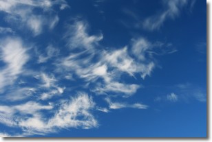
Weather Topic: What are Altostratus Clouds?
Home - Education - Cloud Types - Altostratus Clouds
 Next Topic: Cirrocumulus Clouds
Altostratus clouds form at mid to high-level altitudes
(between 2 and 7 km) and are created by a warm, stable air mass which causes
water vapor
to condense as it rise through the atmosphere. Usually altostratus clouds are
featureless sheets characterized by a uniform color.
In some cases, wind punching through the cloud formation may give it a waved
appearance, called altostratus undulatus. Altostratus clouds
are commonly seen with other cloud formations accompanying them.
Next Topic: Cirrocumulus Clouds
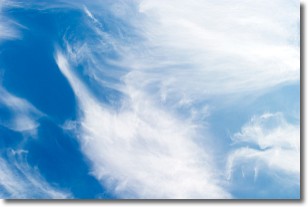
Weather Topic: What are Cirrostratus Clouds?
Home - Education - Cloud Types - Cirrostratus Clouds
 Next Topic: Cirrus Clouds
Cirrostratus clouds are high, thin clouds that form above
20,000 feet and are made mostly of ice crystals. They sometimes look like giant
feathers, horse tails, or curls of hair in the sky.
These clouds are pushed by the jet stream and can move at high speeds reaching
100 mph.
What do they indicate?
They indicate that a precipitation is likely within 24 hours.
Next Topic: Cirrus Clouds
Current conditions powered by WeatherAPI.com


