Weather Alert in Utah
Avalanche Advisory issued February 20 at 5:52AM MST by NWS Salt Lake City UT
AREAS AFFECTED: Wasatch Mountains I-80 North; Wasatch Mountains South of I-80; Western Uinta Mountains; Wasatch Plateau/Book Cliffs; Central Mountains; Southern Mountains
DESCRIPTION: SABSLC * WHAT...The Utah Avalanche Center is warning of dangerous avalanche conditions across all Utah mountains this weekend. This week's heavy snowfall and strong winds overloaded preexisting weak layers, creating a HIGH avalanche danger across the entire state. With improving weather moving in for the weekend, avalanche accidents are likely in the backcountry. There have already been two tragic avalanche fatalities this week, as well as several close calls and numerous backcountry avalanches reported. * WHERE...The mountains of Utah and southeast Idaho. * WHEN...6 AM MST Friday, February 20th 2006 until Monday, February 23rd 2006 at 6 AM MST. * IMPACTS...Dangerous avalanche conditions exist in the backcountry and will persist through the weekend. Natural avalanches are possible, and people are likely to trigger avalanches on slopes steeper than 30 degrees. Dangerous and deadly avalanches can be triggered remotely (from a distance or from below). People leaving ski area boundaries are entering the backcountry where the same dangerous avalanche conditions exist.
INSTRUCTION: Backcountry travelers should consult www.utahavalanchecenter.org or call 1-888-999-4019 for more detailed information. This Bulletin does not apply to ski areas or highways where avalanche hazard reduction measures are performed.
Want more detail? Get the Complete 7 Day and Night Detailed Forecast!
Current U.S. National Radar--Current
The Current National Weather Radar is shown below with a UTC Time (subtract 5 hours from UTC to get Eastern Time).

National Weather Forecast--Current
The Current National Weather Forecast and National Weather Map are shown below.

National Weather Forecast for Tomorrow
Tomorrow National Weather Forecast and Tomorrow National Weather Map are show below.

North America Water Vapor (Moisture)
This map shows recent moisture content over North America. Bright and colored areas show high moisture (ie, clouds); brown indicates very little moisture present; black indicates no moisture.

Weather Topic: What are Cirrus Clouds?
Home - Education - Cloud Types - Cirrus Clouds
 Next Topic: Condensation
Cirrus clouds are high-level clouds that occur above 20,000 feet
and are composed mainly of ice crystals.
They are thin and wispy in appearance.
What do they indicate?
They are often the first sign of an approaching storm.
Next Topic: Condensation
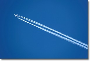
Weather Topic: What are Contrails?
Home - Education - Cloud Types - Contrails
 Next Topic: Cumulonimbus Clouds
A contrail is an artificial cloud, created by the passing of an
aircraft.
Contrails form because water vapor in the exhaust of aircraft engines is suspended
in the air under certain temperatures and humidity conditions. These contrails
are called exhaust contrails.
Another type of contrail can form due to a temporary reduction in air pressure
moving over the plane's surface, causing condensation.
These are called aerodynamic contrails.
When you can see your breath on a cold day, it is also because of condensation.
The reason contrails last longer than the condensation from your breath is
because the water in contrails freezes into ice particles.
Next Topic: Cumulonimbus Clouds
Current conditions powered by WeatherAPI.com


