Weather Alert in Utah
Avalanche Advisory issued February 20 at 5:52AM MST by NWS Salt Lake City UT
AREAS AFFECTED: Wasatch Mountains I-80 North; Wasatch Mountains South of I-80; Western Uinta Mountains; Wasatch Plateau/Book Cliffs; Central Mountains; Southern Mountains
DESCRIPTION: SABSLC * WHAT...The Utah Avalanche Center is warning of dangerous avalanche conditions across all Utah mountains this weekend. This week's heavy snowfall and strong winds overloaded preexisting weak layers, creating a HIGH avalanche danger across the entire state. With improving weather moving in for the weekend, avalanche accidents are likely in the backcountry. There have already been two tragic avalanche fatalities this week, as well as several close calls and numerous backcountry avalanches reported. * WHERE...The mountains of Utah and southeast Idaho. * WHEN...6 AM MST Friday, February 20th 2006 until Monday, February 23rd 2006 at 6 AM MST. * IMPACTS...Dangerous avalanche conditions exist in the backcountry and will persist through the weekend. Natural avalanches are possible, and people are likely to trigger avalanches on slopes steeper than 30 degrees. Dangerous and deadly avalanches can be triggered remotely (from a distance or from below). People leaving ski area boundaries are entering the backcountry where the same dangerous avalanche conditions exist.
INSTRUCTION: Backcountry travelers should consult www.utahavalanchecenter.org or call 1-888-999-4019 for more detailed information. This Bulletin does not apply to ski areas or highways where avalanche hazard reduction measures are performed.
Want more detail? Get the Complete 7 Day and Night Detailed Forecast!
Current U.S. National Radar--Current
The Current National Weather Radar is shown below with a UTC Time (subtract 5 hours from UTC to get Eastern Time).

National Weather Forecast--Current
The Current National Weather Forecast and National Weather Map are shown below.

National Weather Forecast for Tomorrow
Tomorrow National Weather Forecast and Tomorrow National Weather Map are show below.

North America Water Vapor (Moisture)
This map shows recent moisture content over North America. Bright and colored areas show high moisture (ie, clouds); brown indicates very little moisture present; black indicates no moisture.

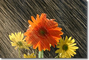
Weather Topic: What is Precipitation?
Home - Education - Precipitation - Precipitation
 Next Topic: Rain
Precipitation can refer to many different forms of water that
may fall from clouds. Precipitation occurs after a cloud has become saturated to
the point where its water particles are more dense than the air below the cloud.
In most cases, precipitation will reach the ground, but it is not uncommon for
precipitation to evaporate before it reaches the earth's surface.
When precipitation evaporates before it contacts the ground it is called Virga.
Graupel, hail, sleet, rain, drizzle, and snow are forms of precipitation, but fog
and mist are not considered precipitation because the water vapor which
constitutes them isn't dense enough to fall to the ground.
Next Topic: Rain
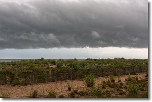
Weather Topic: What are Shelf Clouds?
Home - Education - Cloud Types - Shelf Clouds
 Next Topic: Sleet
A shelf cloud is similar to a wall cloud, but forms at the front
of a storm cloud, instead of at the rear, where wall clouds form.
A shelf cloud is caused by a series of events set into motion by the advancing
storm; first, cool air settles along the ground where precipitation has just fallen.
As the cool air is brought in, the warmer air is displaced, and rises above it,
because it is less dense. When the warmer air reaches the bottom of the storm cloud,
it begins to cool again, and the resulting condensation is a visible shelf cloud.
Next Topic: Sleet
Current conditions powered by WeatherAPI.com


