Weather Alert in Arizona
Extreme Heat Warning issued August 22 at 1:22AM PDT until August 23 at 11:00PM PDT by NWS Las Vegas NV
AREAS AFFECTED: Northwest Plateau; Lake Havasu and Fort Mohave; Northwest Deserts; Lake Mead National Recreation Area; Owens Valley; Death Valley National Park; Western Mojave Desert; Eastern Mojave Desert, Including the Mojave National Preserve; Morongo Basin; Cadiz Basin; San Bernardino County-Upper Colorado River Valley; Lincoln County; Northeast Clark County; Western Clark and Southern Nye County; Las Vegas Valley; Lake Mead National Recreation Area; Southern Clark County
DESCRIPTION: * WHAT...Dangerously hot conditions with temperatures around 105 in Kingman, Golden Valley, Dolan Springs; around 110 in Las Vegas, Pahrump, Barstow, Yucca Valley, Twentynine Palms; around 115 in Laughlin, Bullhead City, Needles, Lake Havasu City; around 120 at Furnace Creek in Death Valley National Park. Expect minimal overnight relief. Major-to-Extreme Heat Risk. In the Owens Valley, temperatures will be around 100 to 105, yielding Moderate Heat Risk. * WHERE...Portions of northwest Arizona, southeast California, and south central and southern Nevada. * WHEN...Until 11 PM PDT /11 PM MST/ Saturday. * IMPACTS...Heat related illnesses increase significantly during extreme heat events.
INSTRUCTION: Drink plenty of fluids, stay in an air-conditioned room, stay out of the sun, and check up on relatives and neighbors. Do not leave young children and pets in unattended vehicles. Car interiors will reach lethal temperatures in a matter of minutes. Take extra precautions when outside. Wear lightweight and loose fitting clothing. Try to limit strenuous activities to early morning or evening. Take action when you see symptoms of heat exhaustion and heat stroke. To reduce risk during outdoor work, the Occupational Safety and Health Administration recommends scheduling frequent rest breaks in shaded or air conditioned environments. Anyone overcome by heat should be moved to a cool and shaded location. Heat stroke is an emergency! Call 9 1 1. Monitor the latest forecasts and warnings for updates.
Want more detail? Get the Complete 7 Day and Night Detailed Forecast!
Current U.S. National Radar--Current
The Current National Weather Radar is shown below with a UTC Time (subtract 5 hours from UTC to get Eastern Time).

National Weather Forecast--Current
The Current National Weather Forecast and National Weather Map are shown below.

National Weather Forecast for Tomorrow
Tomorrow National Weather Forecast and Tomorrow National Weather Map are show below.

North America Water Vapor (Moisture)
This map shows recent moisture content over North America. Bright and colored areas show high moisture (ie, clouds); brown indicates very little moisture present; black indicates no moisture.

Weather Topic: What is Sleet?
Home - Education - Precipitation - Sleet
 Next Topic: Snow
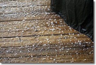
Sleet is a form of precipitation in which small ice pellets are the primary
components. These ice pellets are smaller and more translucent than hailstones,
and harder than graupel. Sleet is caused by specific atmospheric conditions and
therefore typically doesn't last for extended periods of time.
The condition which leads to sleet formation requires a warmer body of air to be
wedged in between two sub-freezing bodies of air. When snow falls through a warmer
layer of air it melts, and as it falls through the next sub-freezing body of air
it freezes again, forming ice pellets known as sleet. In some cases, water
droplets don't have time to freeze before reaching the surface and the result is
freezing rain.
Next Topic: Snow
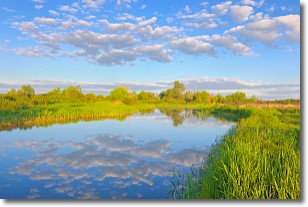
Weather Topic: What are Stratocumulus Clouds?
Home - Education - Cloud Types - Stratocumulus Clouds
 Next Topic: Stratus Clouds
Stratocumulus clouds are similar to altocumulus clouds in their
fluffy appearance, but have a slightly darker shade due to their additional mass.
A good way to distinguish the two cloud types is to hold your hand out and measure
the size of an individual cloud; if it is the size of your thumb it is generally
an altocumulus cloud, if it is the size of your hand it is generally a
stratocumulus cloud.
It is uncommon for stratocumulus clouds to produce precipitation, but if they do
it is usually a light rain or snow.
Next Topic: Stratus Clouds
Current conditions powered by WeatherAPI.com


