Weather Alert in Minnesota
Special Weather Statement issued March 18 at 1:31AM CDT by NWS Duluth MN
AREAS AFFECTED: North Itasca; North Cass; South Itasca; South Cass; Crow Wing; Northern Aitkin; South Aitkin
DESCRIPTION: An area of freezing drizzle is forecast for portions of central and north-central Minnesota early this morning. As of 130 AM freezing drizzle was observed or suspected at Brainerd, Park Rapids, Bemidji, Pine River, and Walker. The area of freezing drizzle extends northwest into southeast Manitoba and should persist through the early morning hours. Freezing drizzle may quickly coat roadways with a thin layer of ice that may be undetectable. Please use extreme caution... especially on bridges...overpasses and around curves. Allow plenty of stopping distance and avoid braking suddenly. Please report freezing drizzle to the National Weather Service in Duluth MN.
INSTRUCTION: N/A
Want more detail? Get the Complete 7 Day and Night Detailed Forecast!
Current U.S. National Radar--Current
The Current National Weather Radar is shown below with a UTC Time (subtract 5 hours from UTC to get Eastern Time).

National Weather Forecast--Current
The Current National Weather Forecast and National Weather Map are shown below.

National Weather Forecast for Tomorrow
Tomorrow National Weather Forecast and Tomorrow National Weather Map are show below.

North America Water Vapor (Moisture)
This map shows recent moisture content over North America. Bright and colored areas show high moisture (ie, clouds); brown indicates very little moisture present; black indicates no moisture.

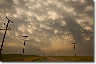
Weather Topic: What are Mammatus Clouds?
Home - Education - Cloud Types - Mammatus Clouds
 Next Topic: Nimbostratus Clouds
A mammatus cloud is a cloud with a unique feature which resembles
a web of pouches hanging along the base of the cloud.
In the United States, mammatus clouds tend to form in the warmer months, commonly
in the Midwest and eastern regions.
While they usually form at the bottom of a cumulonimbis cloud, they can also form
under altostratus, altocumulus, stratocumulus, and cirrus clouds. Mammatus clouds
warn that severe weather is close.
Next Topic: Nimbostratus Clouds
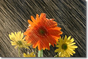
Weather Topic: What is Precipitation?
Home - Education - Precipitation - Precipitation
 Next Topic: Rain
Precipitation can refer to many different forms of water that
may fall from clouds. Precipitation occurs after a cloud has become saturated to
the point where its water particles are more dense than the air below the cloud.
In most cases, precipitation will reach the ground, but it is not uncommon for
precipitation to evaporate before it reaches the earth's surface.
When precipitation evaporates before it contacts the ground it is called Virga.
Graupel, hail, sleet, rain, drizzle, and snow are forms of precipitation, but fog
and mist are not considered precipitation because the water vapor which
constitutes them isn't dense enough to fall to the ground.
Next Topic: Rain
Current conditions powered by WeatherAPI.com


