Weather Alert in Colorado
Flash Flood Warning issued August 27 at 3:04PM MDT until August 27 at 4:45PM MDT by NWS Denver CO
AREAS AFFECTED: Larimer, CO
DESCRIPTION: At 304 PM MDT, Doppler radar indicated thunderstorms producing heavy rain have left the Alexander Mountain Burn Scar. Up to 0.5 inches of rain have fallen. Flooding impacts will continue, but no additional rainfall is expected at this time. Flash flooding is ongoing or expected to begin shortly. Excessive rainfall over the warning area will cause debris flows near steep terrain. The debris flow can consist of rock, mud, vegetation and other loose materials. HAZARD...Life threatening flash flooding. Thunderstorms producing flash flooding in and around the Alexander Mountain Burn Scar. SOURCE...Radar indicated. IMPACT...Life threatening flash flooding of areas in and around the Alexander Mountain Burn Scar. Some locations that will experience flash flooding include... Cedar Cove.
INSTRUCTION: Move away from recently burned areas. Flooding of creeks, roads and normally dry gulches is likely. The heavy rains will likely trigger rockslides, mudslides and debris flows in steep terrain. Be aware of your surroundings and do not drive on flooded roads.
Want more detail? Get the Complete 7 Day and Night Detailed Forecast!
Current U.S. National Radar--Current
The Current National Weather Radar is shown below with a UTC Time (subtract 5 hours from UTC to get Eastern Time).

National Weather Forecast--Current
The Current National Weather Forecast and National Weather Map are shown below.

National Weather Forecast for Tomorrow
Tomorrow National Weather Forecast and Tomorrow National Weather Map are show below.

North America Water Vapor (Moisture)
This map shows recent moisture content over North America. Bright and colored areas show high moisture (ie, clouds); brown indicates very little moisture present; black indicates no moisture.

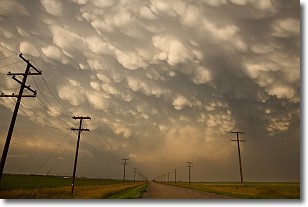
Weather Topic: What are Mammatus Clouds?
Home - Education - Cloud Types - Mammatus Clouds
 Next Topic: Nimbostratus Clouds
A mammatus cloud is a cloud with a unique feature which resembles
a web of pouches hanging along the base of the cloud.
In the United States, mammatus clouds tend to form in the warmer months, commonly
in the Midwest and eastern regions.
While they usually form at the bottom of a cumulonimbis cloud, they can also form
under altostratus, altocumulus, stratocumulus, and cirrus clouds. Mammatus clouds
warn that severe weather is close.
Next Topic: Nimbostratus Clouds
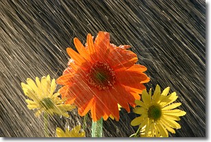
Weather Topic: What is Precipitation?
Home - Education - Precipitation - Precipitation
 Next Topic: Rain
Precipitation can refer to many different forms of water that
may fall from clouds. Precipitation occurs after a cloud has become saturated to
the point where its water particles are more dense than the air below the cloud.
In most cases, precipitation will reach the ground, but it is not uncommon for
precipitation to evaporate before it reaches the earth's surface.
When precipitation evaporates before it contacts the ground it is called Virga.
Graupel, hail, sleet, rain, drizzle, and snow are forms of precipitation, but fog
and mist are not considered precipitation because the water vapor which
constitutes them isn't dense enough to fall to the ground.
Next Topic: Rain
Current conditions powered by WeatherAPI.com


