Weather Alert in California
Dense Smoke Advisory issued September 8 at 1:22AM PDT until September 8 at 11:00AM PDT by NWS Reno NV
AREAS AFFECTED: Mono
DESCRIPTION: * WHAT...Dense smoke reducing visibility to 1 mile or less at times. Smoke will also lead to degraded air quality. * WHERE...Mono County. * WHEN...Until 11 AM PDT this morning. * IMPACTS...Hazardous travel due to reduced visibility, especially along US-395 and over southern Mono County. Poor air quality may cause health issues for those with respiratory illnesses. * ADDITIONAL DETAILS...For details on health impacts and recommended precautions, please consult the Great Basin Unified Air Pollution Control District at GBUAPCD.org and AirNow.gov.
INSTRUCTION: Persons with respiratory illnesses should remain indoors to avoid inhaling smoke.
Want more detail? Get the Complete 7 Day and Night Detailed Forecast!
Current U.S. National Radar--Current
The Current National Weather Radar is shown below with a UTC Time (subtract 5 hours from UTC to get Eastern Time).

National Weather Forecast--Current
The Current National Weather Forecast and National Weather Map are shown below.

National Weather Forecast for Tomorrow
Tomorrow National Weather Forecast and Tomorrow National Weather Map are show below.

North America Water Vapor (Moisture)
This map shows recent moisture content over North America. Bright and colored areas show high moisture (ie, clouds); brown indicates very little moisture present; black indicates no moisture.

Weather Topic: What are Stratus Clouds?
Home - Education - Cloud Types - Stratus Clouds
 Next Topic: Wall Clouds
Stratus clouds are similar to altostratus clouds, but form at a
lower altitude and are identified by their fog-like appearance, lacking the
distinguishing features of most clouds.
Stratus clouds are wider than most clouds, and their base has a smooth, uniform
look which is lighter in color than a nimbostratus cloud.
The presence of a stratus cloud indicates the possibility of minor precipitation,
such as drizzle, but heavier precipitation does not typically arrive in the form
of a stratus cloud.
Next Topic: Wall Clouds
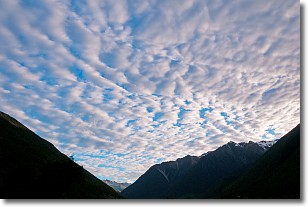
Weather Topic: What are Altocumulus Clouds?
Home - Education - Cloud Types - Altocumulus Clouds
 Next Topic: Altostratus Clouds
Similar to cirrocumulus clouds, altocumulus clouds are
characterized by cloud patches. They are distinguished by larger cloudlets
than cirrocumulus clouds but are still smaller than stratocumulus clouds.
Altocumulus clouds most commonly form in middle altitudes (between 2 and 5 km)
and may resemble, at times, the shape of a flying saucer.
These uncommon formations, called altocumulus lenticularis, are created by uplift
in the atmosphere and are most often seen in close proximity to mountains.
Next Topic: Altostratus Clouds
Current conditions powered by WeatherAPI.com


