Weather Alert in Idaho
Avalanche Watch issued February 22 at 10:36PM PST by NWS Spokane WA
AREAS AFFECTED: Bonner, ID; Boundary, ID; Shoshone, ID
DESCRIPTION: AVAOTX The following message is transmitted at the request of the Idaho Panhandle Avalanche Center. ...AVALANCHE WATCH ISSUED BY THE IDAHO PANHANDLE AVALANCHE CENTER... 19:00 PST Sun Feb 22 2026 The Idaho Panhandle Avalanche Center in Sandpoint has issued a BACKCOUNTRY AVALANCHE WATCH for the following areas: NWS Missoula MT - MTZ001 (MTZ001) NWS Spokane WA - ID 017 (Bonner County)...ID 021 (Boundary County)...ID 079 (Shoshone County) * WHAT...An Avalanche Watch is in effect from Sunday 7 PM PST to Monday 4 PM PST. Very dangerous avalanche conditions are likely to develop by Monday afternoon and raise the danger to High (Level 4of5). * WHERE...The Selkirk, West and East Cabinet, Purcell, and Bitterroot Mountains - Silver Valley above 4,000 feet. * WHEN...In effect from Sun 19:00 PST to Mon 16:00 PST. * IMPACTS...A warm, wet storm will deliver moderate to heavy snowfall to the snowpack. The new snowfall may add enough weight to the snowpack to overload fragile weak snow layers and cause a widespread cycle of avalanches large enough to bury, injure, or kill a person. Some of these avalanches could release naturally, propagate widely across terrain features like ridges, and run long distances into mature forests, valley floors, or flat terrain. It will become very easy for backcountry travelers to trigger them. * PRECAUTIONARY / PREPAREDNESS ACTIONS...Travel in or below avalanche terrain is not recommended during this period. Consult http://www.idahopanhandleavalanche.org/ or www.avalanche.org for more detailed information. Similar avalanche danger may exist at locations outside the coverage area of this or any avalanche center.
INSTRUCTION: N/A
Want more detail? Get the Complete 7 Day and Night Detailed Forecast!
Current U.S. National Radar--Current
The Current National Weather Radar is shown below with a UTC Time (subtract 5 hours from UTC to get Eastern Time).

National Weather Forecast--Current
The Current National Weather Forecast and National Weather Map are shown below.

National Weather Forecast for Tomorrow
Tomorrow National Weather Forecast and Tomorrow National Weather Map are show below.

North America Water Vapor (Moisture)
This map shows recent moisture content over North America. Bright and colored areas show high moisture (ie, clouds); brown indicates very little moisture present; black indicates no moisture.

Weather Topic: What are Cumulonimbus Clouds?
Home - Education - Cloud Types - Cumulonimbus Clouds
 Next Topic: Cumulus Clouds
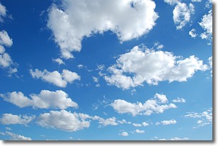
The final form taken by a growing cumulus cloud is the
cumulonimbus cloud, which is very tall and dense.
The tower of a cumulonimbus cloud can soar 23 km into the atmosphere, although
most commonly they stop growing at an altitude of 6 km.
Even small cumulonimbus clouds appear very large in comparison to other cloud types.
They can signal the approach of stormy weather, such as thunderstorms or blizzards.
Next Topic: Cumulus Clouds
Weather Topic: What is Drizzle?
Home - Education - Precipitation - Drizzle
 Next Topic: Evaporation
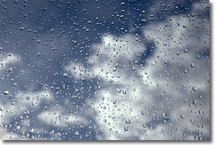
Drizzle is precipitation in the form of water droplets which are
smaller than raindrops.
Drizzle is characterized by fine, gently falling droplets and typically does not
impact human habitation in a negative way. The exception to this is freezing drizzle,
a condition where drizzle freezes immediately upon reaching earth's surface.
Freezing drizzle is still less dangerous than freezing rain, but can
potentially result in hazardous road conditions.
Next Topic: Evaporation
Current conditions powered by WeatherAPI.com


