Weather Alert in Oregon
Flood Watch issued February 23 at 10:01AM PST until February 25 at 4:00AM PST by NWS Medford OR
AREAS AFFECTED: South Central Oregon Coast
DESCRIPTION: ...The National Weather Service in Medford OR has issued a Flood Watch for the following rivers in Oregon... South Fork Coquille River at Myrtle Point affecting South Central Oregon Coast zone. .A Pineapple Express will bring heavy rain to the Coquille River basin, which could result in minor flooding due to excessive runoff. * WHAT...Minor flooding is possible. * WHERE...South Fork Coquille River at Myrtle Point. * WHEN...Through early Wednesday morning. The river is expected to crest Tuesday afternoon. * IMPACTS...At 30.0 feet, Agricultural and pasture land begins to flood. Impacts on cattle grazing are possible. * ADDITIONAL DETAILS... - At 9:20 AM PST Monday the stage was 24.0 feet. - Forecast...Flood stage may be reached based on the latest forecast information. - Flood stage is 33.0 feet. - http://www.weather.gov/safety/flood
INSTRUCTION: If you are in the watch area, remain alert to possible flooding. Additional information is available at www.weather.gov. The next statement will be issued Tuesday morning at 1000 AM PST.
Want more detail? Get the Complete 7 Day and Night Detailed Forecast!
Current U.S. National Radar--Current
The Current National Weather Radar is shown below with a UTC Time (subtract 5 hours from UTC to get Eastern Time).

National Weather Forecast--Current
The Current National Weather Forecast and National Weather Map are shown below.

National Weather Forecast for Tomorrow
Tomorrow National Weather Forecast and Tomorrow National Weather Map are show below.

North America Water Vapor (Moisture)
This map shows recent moisture content over North America. Bright and colored areas show high moisture (ie, clouds); brown indicates very little moisture present; black indicates no moisture.

Weather Topic: What is Freezing Rain?
Home - Education - Precipitation - Freezing Rain
 Next Topic: Graupel
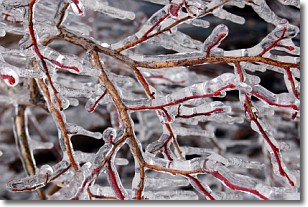
Freezing rain is a condition where precipitation which has fallen in the form of
water droplets reaches temperatures which are below freezing and freezes upon
coming into contact
with surface objects. The result of this precipitation is a glaze of ice which
can be damaging to plants and man-made structures. A severe onset of freezing
rain which results in a very thick glaze of ice is known as an ice storm.
Next Topic: Graupel
Weather Topic: What is Hail?
Home - Education - Precipitation - Hail
 Next Topic: Hole Punch Clouds
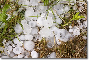
Hail is a form of precipitation which is recognized by large solid balls or
clumps of ice. Hail is created by thunderstorm clouds with strong updrafts of wind.
As the hailstones remain in the updraft, ice is deposited onto them until their
weight becomes heavy enough for them to fall to the earth's surface.
Hail storms can cause significant damage to crops, aircrafts, and man-made structures,
despite the fact that the duration is usually less than ten minutes.
Next Topic: Hole Punch Clouds
Current conditions powered by WeatherAPI.com


